संक्षेप में: जयपुर विकास प्राधिकरण (जेडीए) जयपुर क्षेत्र के लिए मास्टर डेवलपमेंट प्लान 2025 प्रकाशित करता है — चार खंड और चार मैपबुक। भू-उपयोग योजना बताती है कि जेडीए किस क्षेत्र के लिए कौन-सा उपयोग प्रस्तावित करता है। 26 अक्टूबर 2026 को अपडेट हुए जेडीए पेज पर यही योजना दिखती है; वहाँ “MDP-2047 प्रश्नावली” का लिंक है, नई योजना नहीं। हमने जेडीए की भू-उपयोग योजना को अपने नक्शों पर सांकेतिक परत के रूप में जोड़ा है। एग्रीज़मीन एक स्वतंत्र निजी मंच है — सरकारी संस्था नहीं, और जेडीए से संबद्ध नहीं।
What the plan is योजना क्या है
MDP-2025 is JDA’s plan for how land in the Jaipur Region is to be used up to 2025. Volume 1 describes the region as it was surveyed; Volume 2 is the development plan; Volume 3 covers the satellite towns and growth centres; Volume 4 holds the Development Promotion & Control Regulations — the rules on what may be built in each use zone. The map books show the base map, the existing land use, the land utilisation of the whole region, and the proposed Land Use Plan.
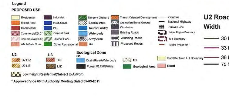
The city Land Use Plan sheet is drawn at 1:50,000 and carries JDA map number JDA/MP/MDP/LU/11/02. Its legend says it was “approved vide 60th Authority meeting dated 05-09-2011”. The same map book divides the U1 (urban) area into numbered 1:25,000 sheets.
खंड 1 क्षेत्र की स्थिति, खंड 2 विकास योजना, खंड 3 उपनगर और विकास केंद्र, और खंड 4 विकास नियंत्रण विनियम हैं। शहर की भू-उपयोग योजना 1:50,000 पर है (नक्शा संख्या JDA/MP/MDP/LU/11/02); उस पर लिखा है कि यह 05-09-2011 की प्राधिकरण की 60वीं बैठक में स्वीकृत हुई।
The documents, on JDA’s site दस्तावेज़ — जेडीए की साइट पर
Each link opens JDA’s own PDF, so you always get JDA’s current copy. Source: Jaipur Development Authority, as listed on its MDP-2025 page on 29 October 2026.
How to read the Land Use Plan भू-उपयोग योजना कैसे पढ़ें
Find the place, read the colour under it, and match the colour to the legend. The legend groups the proposed uses: residential and mixed residential; commercial (including wholesale); industrial; institutional and public utility (P.U.); central and district parks and other recreational use; nursery and orchard; special area, tourist facility, water body and army area; transit-oriented development; and circulation (existing, widening and proposed roads, with widths from 30 to 80 metres). Hatched areas mark the U2 and U3 zones, the ecological zone (G1: drains, rivers and water bodies; forest and hills — and G2) and rural land. A separate pattern marks low-height residential areas near the airport.
JDA’s own note on the sheet says the map is a guide to the type of land use, that the zoning regulations decide what is allowed, that zonal plans are to be prepared, and that land-use changes follow the law. So a colour on this map is where you start, not the answer for a plot.
जगह ढूँढें, उसके नीचे का रंग देखें और लेजेंड से मिलाएँ। जेडीए का नोट कहता है कि यह नक्शा भू-उपयोग के प्रकार की मार्गदर्शिका है; किसी प्लॉट पर क्या अनुमत है, यह ज़ोनिंग विनियम और ज़ोनल प्लान तय करते हैं।
The plan on our maps हमारे नक्शों पर योजना
JDA’s city Land Use Plan sheet now shows as a layer on the Belt Explorer and on the Buy Land map (layer “JDA Master Plan 2025”), and in the AgriZameen GPS app (Land layers → Infrastructure). An opacity slider lets you see the roads and fields underneath, and JDA’s legend opens beside it.
How it was lined up: the sheet was placed on the map from its own latitude and longitude ticks and re-drawn in the web-map projection. A scanned 1:50,000 sheet placed that way can be off by a few hundred metres, so it is indicative: good for seeing which zone an area is in, not for deciding the edge of a zone at a particular plot. It covers roughly 75.57°E to 75.97°E and 26.65°N to 27.12°N — the city and its ring. Our focus belt around Phulera and Sambhar is outside this sheet; there, ask the authority that plans your tehsil.
यह परत बेल्ट एक्सप्लोरर, बाय लैंड नक्शे और एग्रीज़मीन जीपीएस ऐप में है। इसे शीट के अक्षांश-देशांतर निशानों से नक्शे पर बैठाया गया है, इसलिए कुछ सौ मीटर का अंतर संभव है — यह सांकेतिक है, प्लॉट की सीमा तय करने के लिए नहीं।
Before you buy near a zone line ज़ोन की सीमा के पास ख़रीदने से पहले
- Read the colour on the plan, then ask JDA which zonal plan covers the land and what use it shows for the khasra.
- Read the regulations in Volume 4 for that use: what may be built, and what needs permission.
- Check whether the land has been converted from agricultural use (Section 90-A) and whether the layout is approved — see our guide to land conversion under Section 90-A.
- Check the jamabandi and the khasra map for the title, and consult a qualified professional before you pay.
ख़रीदने से पहले: जेडीए से ज़ोनल प्लान और उस खसरे का भू-उपयोग पूछें; खंड 4 के विनियम पढ़ें; धारा 90-ए रूपांतरण और ले-आउट स्वीकृति जाँचें; जमाबंदी और खसरा नक्शा देखें, और भुगतान से पहले विशेषज्ञ से सलाह लें।
Watching for a new plan नई योजना पर नज़र
JDA’s page links an “MDP-2047 Questionnaire”. Until JDA publishes a new plan on that page, MDP-2025 is the one shown there. We check the page and list any change in our news.
Questions सवाल
Where can I download the Jaipur master plan 2025?
On JDA’s Master Development Plan 2025 page. We link each of its four volumes and four map books above, so the file you open is always JDA’s current copy.
How do I check the land use of a plot in Jaipur?
Find the area on the Land Use Plan and match its colour to the legend, then ask JDA for the zonal plan and the use it shows for that khasra. The city plan is drawn at 1:50,000, so it shows zones, not plot edges.
Is there a new Jaipur master plan, MDP-2047?
On 29 October 2026 JDA’s page still shows MDP-2025 and links an MDP-2047 questionnaire, not a published plan. We will add a new plan when JDA publishes it.
Can I see the master plan on a map?
Yes. Our Belt Explorer, the Buy Land map and the AgriZameen GPS app show JDA’s Land Use Plan as an indicative layer with an opacity slider and JDA’s legend.
Does the master plan colour mean I can build on the land?
No. JDA’s note says the zoning regulations decide what is allowed, and land in agricultural use still needs conversion and an approved layout. Treat the colour as the first check, not permission.
Sources स्रोत
- Jaipur Development Authority — Master Development Plan 2025 page (page last updated 26 October 2026; read 29 October 2026).
- JDA, Mapbook 4 — Land Use Plan, Jaipur, Master Development Plan 2025 (map no. JDA/MP/MDP/LU/11/02; legend note: approved vide 60th Authority meeting, 05-09-2011).