Before you buy farmland near a city, check what the master plan shows for it: agriculture, residential, commercial, an eco-sensitive zone, a road. The Urban GIS Portal shows this on a map. This page walks through it screen by screen; every screenshot is real and marked. For more on the portal, read what Urban GIS shows. General information, not legal advice.
On screen, step by step
1 a step to doA another option check thisBlurred: names, numbers and emblems we do not publish
Open the Urban GIS Portal and choose district and city
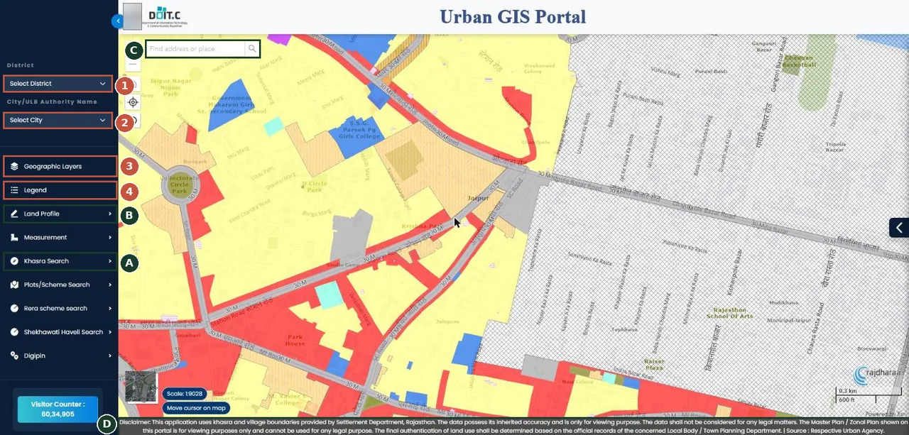
Urban GIS Portal (opened from the JDA 'Jaipur Master Plan 2025' tile). Colours on the map are master-plan land uses. अर्बन जीआईएस पोर्टल: ज़िला और शहर चुनें। नक्शे के रंग मास्टर प्लान का भू-उपयोग बताते हैं।Screenshot of the official portal, taken 15 November 2026. AgriZameen is not affiliated with it. Parts are blurred by AgriZameen. - 1Select District
- 2Select City / ULB
- 3Geographic Layers
- 4Legend (what each colour means)
- AKhasra Search
- BLand Profile
- CFind address or place
- DRead the disclaimer: viewing only, not for legal use
Open Khasra Search and choose tehsil, village and khasra
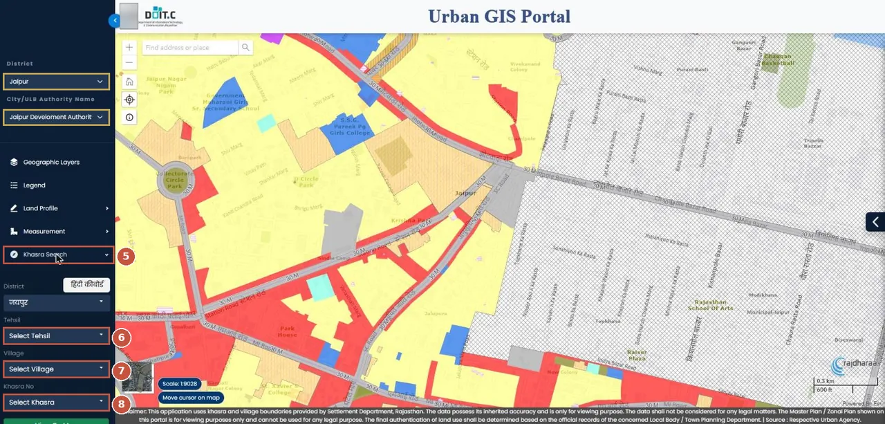
Pick district and city, then open Khasra Search. Pick tehsil, village and khasra; the map zooms to that khasra over the master-plan colours. "Khasra Search" खोलें: तहसील, गाँव और खसरा चुनें।Screenshot of the official portal, taken 15 November 2026. AgriZameen is not affiliated with it. Parts are blurred by AgriZameen. - District (done in steps 1–2)
- City / ULB (done in steps 1–2)
- 5Khasra Search
- 6Tehsil
- 7Village
- 8Khasra No (from your jamabandi)
Read the colour in the Legend
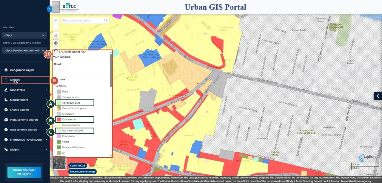
Legend: match the colour under your khasra to a land use (agriculture, residential, commercial, eco-sensitive and so on). "Legend" में रंग का अर्थ देखें — कृषि, आवासीय, वाणिज्यिक आदि।Screenshot of the official portal, taken 15 November 2026. AgriZameen is not affiliated with it. Parts are blurred by AgriZameen. - 9Legend
- 10Land-use colour key
- AAgriculture Land
- BCommercial
- CEco-Sensitive Zone
- Why it mattersFarmland inside a master plan may be marked for another use, and a road or green belt can cross it. Land use affects conversion and what can be built.
- Stop hereWe do not show a real khasra on the map. Check your own khasra, then confirm the land use in writing from the local body.
Read the disclaimer
- The portal's own disclaimer, printed at the foot of the map, says the master plan shown is for viewing only and cannot be used for any legal purpose.
- It says the final word on land use comes from the official records of the local body or town planning department.
- So treat the colour as a first check. Before you pay, ask the local body or a town planner for the land use in writing.
अर्बन जीआईएस पोर्टल पर: ज़िला → शहर/प्राधिकरण → "Khasra Search" → तहसील → गाँव → खसरा → "Legend" में रंग का अर्थ। पोर्टल का अपना अस्वीकरण कहता है कि नक्शा केवल देखने के लिए है, कानूनी काम के लिए नहीं; अंतिम भू-उपयोग स्थानीय निकाय या नगर नियोजन विभाग के रिकॉर्ड से तय होता है। स्क्रीनशॉट 15 नवंबर 2026 के हैं।
FAQ
Is the Urban GIS land use final?
No. The portal's disclaimer says the map is for viewing only; the local body's or town planning department's records decide.
What do I need for a Khasra Search?
The district, city or authority, tehsil, village and the khasra number from your jamabandi.
Are these real screenshots?
Yes. They were taken on the official portal in a desktop browser on 15 November 2026. Names, record numbers, rate figures and the State Emblem are blurred by AgriZameen.
The portal looks different now. What should I do?
Portals change their screens. Follow the same menu names; if a step has moved, tell us on +91 70149 86988 and we will re-check the screens.
Sources
- Urban GIS Portal (opened from the JDA site), 15 November 2026: rajdharaa.rajasthan.gov.in