The AgriZameen GPS app started as a way to measure land: tap the corners on a satellite map, or walk the boundary with your phone, and read the area. It still does exactly that. What is new is that the same map now shows the land listed on AgriZameen, and gives buyers and sellers a careful way to share the details that matter.
Everything on this page is information, not advice. A listing on the map is not a recommendation, no price or return is suggested anywhere in the app, and nothing it shows replaces checking the official land record yourself.
Listings on the map, as an area — never as a plot
Open the app and the listings layer is already on. Each published listing appears as a gold-edged circle with a small label showing the village and, where the seller has published it, the area.
Each listing is drawn as a circle about one kilometre across, around a centre rounded to roughly village level. It tells you which area to look at, not which field. The exact boundary is shown only to a buyer the seller has agreed to share it with.
That is deliberate. A pin would claim a precision we refuse to publish, and it would point strangers at somebody's field. The circles also do not get in the way of measuring: you can still tap corners inside one.
Everything sits behind one Layers button: the listings, a Fields view of satellite imagery (labelled, always, as not a legal boundary — a field edge in a photograph is not a line in any record), and My parcels.
The listing card
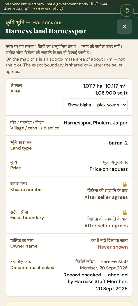
Tap a listing and a card opens, Hindi line first. It shows what the seller and the team have published and nothing else:
- Area in hectares, square metres and square feet. Bigha appears only after you pick your local bigha standard, because a bigha in one village is not a bigha in the next.
- Village, tehsil and district, as recorded on the listing.
- Price on request. The app does not print a price.
- Khasra number and exact boundary — locked, marked After seller agrees.
- Owner name — marked Never shown. It is not shared even when a seller agrees to share the khasra.
- Documents checked — a line appears only where someone on the team has recorded a check, with the date. Where nothing is recorded, it says so.
Requesting the details
If a listing interests you, tap Request details. You will be asked to sign in once, so the seller knows the request is from a real person.
Nobody by default. The khasra number and the exact boundary stay locked until the seller chooses to share them with one particular buyer. That buyer then sees them with their own name written across the screen, and the seller can withdraw the share at any time.
No. The seller sees your first name and the first letter of your surname, and whether the AgriZameen team has checked your ID. Phone numbers and email addresses stay with the AgriZameen team, which handles calls and site visits.
For sellers: one question, two buttons
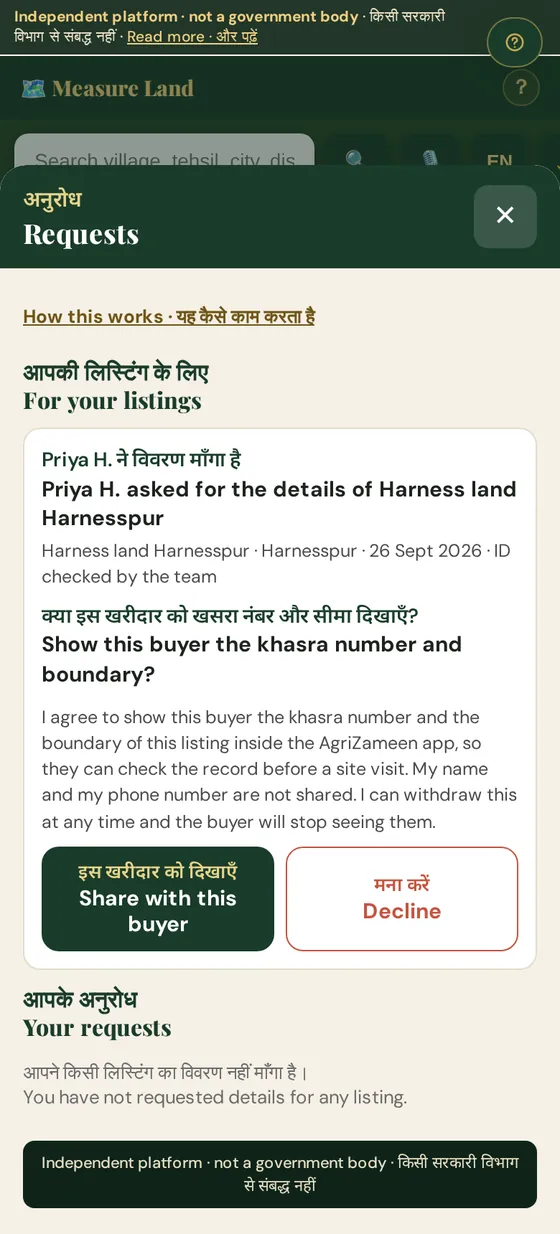
When a buyer asks, a seller sees one question — show this buyer the khasra number and boundary? — and two large buttons: Share with this buyer or Decline. The words you agree to are shown right above the buttons, and the app records your decision, the time and the version of those words as the record of your consent.
A share covers that one buyer and that one listing. You can withdraw it at any time from the same screen; the buyer stops seeing the details at once. If your listing is taken off the site, every share for it stops too. The purpose is narrow — so a serious buyer can check the record before a site visit — and calls and visits still go through the AgriZameen team.
My parcels: your own boundaries, kept private
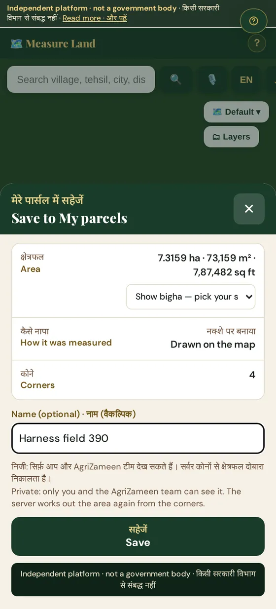
Measure a boundary with the app's own tools — tap the corners, or walk the edge with GPS — and, once it closes, a Save to My parcels button appears. Give it a name if you like. The server works out the area again from the corners rather than trusting the phone.
Only you and the AgriZameen team. A saved parcel is never shown on the public map, in a listing or to another user. You can delete it from the app at any time.
No. A phone GPS or a boundary drawn on a satellite image gives a useful estimate, not a survey. For a transaction, rely on the area recorded in the land record and on a demarcation by the revenue office.
What the app never shows
- A khasra or khata number, an owner's name or an exact coordinate on any public screen, map or shared image.
- A price, a rate or a forecast of any kind.
- Anyone's phone number to anyone else.
- A government map: the app does not fetch maps from any land-records portal. To see the official khasra map, use the state's own portal — our Bhu-Naksha guide shows how for Rajasthan.
Before you rely on anything you see
The map gets you to the right area and the right conversation. It does not replace the checks: read the jamabandi, match the khasra against the official record, and follow our buying checklist. For how the app handles your data, see section 5 of the privacy policy.
हिंदी में
एग्रीज़मीन GPS ऐप में अब वही नक्शा, जिस पर आप ज़मीन नापते हैं, एग्रीज़मीन की लिस्टिंग भी दिखाता है। हर लिस्टिंग लगभग एक किलोमीटर के गोले के रूप में दिखती है — यह इलाका बताता है, खेत नहीं। लिस्टिंग पर टैप करने पर कार्ड खुलता है: मूल्य अनुरोध पर, खसरा नंबर और सटीक सीमा “विक्रेता की सहमति के बाद”, और मालिक का नाम कभी नहीं दिखाया जाता।
“विवरण माँगें” दबाने पर विक्रेता को सिर्फ़ आपका पहला नाम और उपनाम का पहला अक्षर दिखता है, फ़ोन नंबर नहीं। विक्रेता “इस खरीदार को दिखाएँ” या “मना करें” चुनता है, और कभी भी सहमति वापस ले सकता है। अपने नापे हुए खेत “मेरे पार्सल” में सहेजें — ये सिर्फ़ आप और एग्रीज़मीन टीम देख सकते हैं। फ़ोन से नापा गया क्षेत्रफल अनुमान है, सर्वे नहीं; सौदे से पहले सरकारी रिकॉर्ड से खुद जाँचें।
Questions we are asked about this
Does the Land Map show the exact location of a listed plot?
No. Each listing is drawn as a circle about one kilometre across, around a centre rounded to roughly village level. It tells you which area to look at, not which field. The exact boundary is shown only to a buyer the seller has agreed to share it with.
Who can see the khasra number of a listing?
Nobody by default. The khasra number and the exact boundary stay locked until the seller chooses to share them with one particular buyer. That buyer then sees them with their own name written across the screen, and the seller can withdraw the share at any time.
Will the seller see my phone number when I request details?
No. The seller sees your first name and the first letter of your surname, and whether the AgriZameen team has checked your ID. Phone numbers and email addresses stay with the AgriZameen team, which handles calls and site visits.
Who can see the parcels I save in My parcels?
Only you and the AgriZameen team. A saved parcel is never shown on the public map, in a listing or to another user. You can delete it from the app at any time.
Is the area the app measures a legal measurement?
No. A phone GPS or a boundary drawn on a satellite image gives a useful estimate, not a survey. For a transaction, rely on the area recorded in the land record and on a demarcation by the revenue office.
AgriZameen is an independent platform, not a government body, and is not affiliated with any land-records department. Verify every record on the official portal and at the tehsil before you transact. Nothing here is legal or investment advice, and no returns are promised.